Yaoundé: The City That Climbs
On seven green hills in the heart of Central Africa sits a capital that refuses to lie flat. Yaoundé is a city of altitude and contradiction — French in tongue, divided in memory, and quietly central to one of Africa's most unusual national stories.
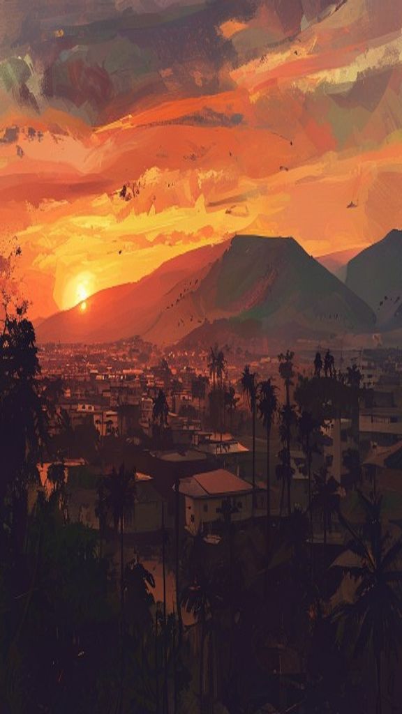
The first thing Yaoundé does is make you climb. Roads that begin as smooth tarmac surrender to red laterite dirt halfway up a ridge; motorbike-taxis lean into switchbacks their riders have memorised by feel; and just when you think you've reached the top of the city, another hill rises behind it. Cameroon's capital does not sprawl politely across a plain like so many administrative cities. It is wedged into the folds of the land, seven hills deep, and that single geographic fact has shaped almost everything about how a million and a half people live, move, and remember here.
Seven Hills, One Climate of Their Own
Yaoundé invites the comparison to Rome so readily that locals make it themselves: a city of seven hills, built where the land would not stay still. But the hills here are not weathered into gentle history. They are abrupt and green and very much in charge. The Mfoundi River threads through the valley floor downtown, gathering markets along its banks and flooding them after a heavy rain, while the wealthier quarters climb away from the water toward cooler, drier air. The altitude is the city's quiet gift. At roughly 700 metres above sea level, Yaoundé sits high enough to escape the worst of the equatorial heat that punishes lower cities at the same latitude. Mornings arrive cool and often wrapped in mist that pools between the ridges before the sun burns it off; afternoons warm but rarely scorch. The rhythm of the city bends to this — markets surge at dawn, the heaviest work is done before noon, and the day softens into something slower by late afternoon. What the topography really dictates, though, is who lives where. Bastos, the diplomatic quarter, sits high and leafy, embassies hidden behind walls and flowering trees. Lower down, valley neighbourhoods inherit the water the hills shed each rainy season. There is no single skyline to photograph, no postcard angle, because no one point can see the whole of Yaoundé. You catch it instead in fragments — rounding a corner expecting more stalls and finding the entire city spread below you, rooftops and forest canopy tangled in the evening haze.
A Capital Born of Trade and Empire
Yaoundé's beginnings are tangled in the long arc of colonial Central Africa. German agents established a post here in the late 1880s, drawn by the trade routes and the agricultural promise of the surrounding hills, and adopted a version of the name of the Ewondo communities already living across this high ground — Jaunde. For a few decades the settlement grew as a modest German station, far from the coast and its busier rivals. The First World War redrew everything. Germany lost its African territories, and Cameroon was partitioned between France and Britain. France took the larger eastern share and, in time, made Yaoundé its administrative seat — a role the city has never relinquished. The choice was partly geographic: inland, elevated, defensible, and healthier than the humid coast. From that decision flows the city's entire modern character as a place of government and paperwork rather than ports and cargo. That role still defines Yaoundé's relationship with its great rival, Douala, four hours away on the coast. Douala moves the money; Yaoundé moves the policy. Ask anyone on the long road between them which city truly runs Cameroon and you'll get a passionate answer that depends entirely on where they were born. The two cities split the national identity between commerce and authority, and the friendly rivalry between them is one of the most reliable conversations in the country.
The Monument That Marks a Reunion
Near the city centre, rising out of a busy roundabout, stands the Monument de la Réunification — a sculpted column most residents pass without a glance, the way you stop seeing the furniture in your own home. But it commemorates something genuinely rare. Not independence. Reunion. When the partition of Cameroon ended, the two halves had spent four decades apart — French in the east, British administration in the west, with separate languages, school systems, and currencies growing up side by side. French Cameroun became independent in 1960. The following year, the British-administered southern territory held a vote and chose to join its newly independent neighbour rather than remain attached to Nigeria. The monument marks that choice to become one country. The legacy is written into Cameroon itself: it remains one of the few officially bilingual nations in Africa, French and English both stamped on its currency and taught in its schools. Yaoundé sits firmly on the Francophone side — its street signs, ministries and market haggling almost entirely in French — but the country's dual heritage runs underneath everything, and the relationship between the Francophone majority and the Anglophone minority is a live and sometimes painful conversation rather than a closed chapter. The monument in the traffic circle is the one place in the city that says so out loud.
What this teaches us about geography
Cameroon is nicknamed "Africa in miniature," and it is geography, not tourism brochures, that earns the title. Inside its borders the country holds Atlantic coast, equatorial rainforest, volcanic highlands and the dry Sahelian north — a range of landscapes that elsewhere would take many countries to assemble. More than 250 ethnic groups and around two hundred languages live across that span, and a remarkable number of them pass through Yaoundé for work, study or government. You hear the country's diversity before you can name it. An afternoon at Mokolo market moves through several languages between one stall and the next, French stepping in as the bridge when nothing else will serve. Smoked fish hauled up from the coast sits beside cassava, plantain and goods trucked overland from Douala. And the food carries the same geography the languages do: ndolé — bitterleaf simmered with groundnuts, fish or beef — is widely considered Cameroon's national dish, and a plate of it beside grilled coastal fish and roadside-fried plantain tastes of forest, farmland and ocean at once. Spend long enough here and the lesson settles in: geography in Yaoundé is not a subject to be studied but the weather of daily life. The seven hills are why a flood in the valley becomes everyone's problem within hours. The Reunification Monument is why a debate about language and belonging plays out in classrooms and Parliament alike. The crowd at Mokolo is why you can eat across three landscapes without leaving a city block. Yaoundé resists a single image because it is many cities at once — hill and valley, French and English, capital and rival — and that refusal is precisely what makes it worth understanding.